


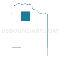
Precinct 3, Cedar County, Nebraska
About
Outline

Summary
| Unique Area Identifier | 612562 |
| Name | Precinct 3 |
| County | Cedar County |
| State | Nebraska |
| Area (square miles) | 36.15 |
| Land Area (square miles) | 36.15 |
| Water Area (square miles) | 0.00 |
| % of Land Area | 100.00 |
| % of Water Area | 0.00 |
| Latitude of the Internal Point | 42.74301800 |
| Longtitude of the Internal Point | -97.30835630 |
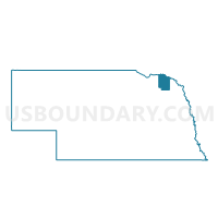
Maps

Graphs
Select a template below for downloading or customizing gragh for Precinct 3, Cedar County, Nebraska


Neighbors
Neighoring Voting District (by Name) Neighboring Voting District on the Map
- Precinct 1, Cedar County, NE
- Precinct 2, Cedar County, NE
- Precinct 4, Cedar County, NE
- Precinct 6, Cedar County, NE
- Precinct 7, Cedar County, NE
- Precinct 8, Cedar County, NE
- Precinct 9, Cedar County, NE
Top 10 Neighboring County Subdivision (by Population) Neighboring County Subdivision on the Map
- Precinct 2, Cedar County, NE (468)
- Precinct 5, Cedar County, NE (423)
- Precinct 1, Cedar County, NE (374)
- Precinct 4, Cedar County, NE (345)
- Precinct 3, Cedar County, NE (339)
- Precinct 9, Cedar County, NE (249)
- Precinct 8, Cedar County, NE (236)
- Precinct 10, Cedar County, NE (181)
- Precinct 9A, Cedar County, NE (162)
Top 10 Neighboring Place (by Population) Neighboring Place on the Map
Top 10 Neighboring Unified School District (by Population) Neighboring Unified School District on the Map
- Hartington Public Schools, NE (3,332)
- Crofton Community Schools, NE (2,265)
- Wynot Public Schools, NE (710)